
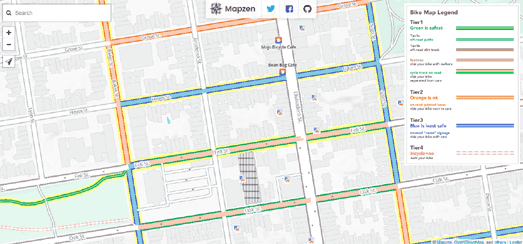
Mapzen's new Bike Map can help you navigate a safer way to cycle. The Bike Map colors roads and bike paths based on three different tiers of safety, allowing you to tell at a glance which roads are the safest for cyclists.
The three tiers are:
- Green (safest) - off road bike paths
- Orange (less safe) - on road bike lanes
- Blue (least safe) - no bike lanes
The Bike Map uses data from Open Street Map. This means that the map works for anywhere in the world. It also means that if you don't think the map is accurate enough in your area you can improve the map by contributing to Open Street Map.
If you want to use the Bike Map in your own maps you can! You just need to add the Walkabout basemap style to a Tangram map and turn on the bike tier data. The Mapzen Blog has more details on how to add the Bike Map to your own maps. It also has more details on how the map was designed and the other biking features that you can find on the Bike Map basemap.
No comments:
Post a Comment